
How far, on average, are your customers willing to travel to purchase their next vehicle from your dealership?
For those of you out there in digital dealership land looking for a way to get absolutely buried in insane data diving that provides easy, actionable, results, boy do I have your fix! Geo-coding.
Geo-coding is the practice of taking location data coordinates and mapping them, usually via CSV file, to a graphical map interface. Or in other words, pulling zip codes out of your CRM sales folder (again in CSV text tab-delimited) and uploading it to one of several Geo-coding web stations.
My personal favorite and easily the most convenient one out there for those running their own SEM campaigns in Adwords is, you guessed it, Google MapsEngine.
Sound Good? Let’s Get Started…
Mapsengine is free to use providing the .csv file you upload contains fewer than 100 rows of data. However, if your intention is work smarter and not necessarily harder (and I certainly hope it is) you can get unlimited uploaded and file size by paying the very reasonable $5 fee per year. Do it this way, TRUST ME! The best way to use Maps Engine is to create an account using the Google account already associated to your Adwords, Analytics, etc accounts. It’s very simple and only takes a few minutes to be up and running.
Before we start GEO-coding we’ll need to get a useful file. You can really start anywhere New Sales, Used Sales, Fixed Ops, Lessees vs those who finance, and many, many more. My approach has always been, “Shoot first and if you miss simply shoot again”, so we’re going to just dive into an immediately useful GEO-coding activity.
Let’s Begin…
First thing you have to do is fire up your CRM and pull a search that includes all of the following criteria and is exportable in CSV comma-delimited format.
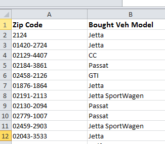
We want all New vehicles sold in the last 4 full months making sure that we include: Model | Zip Code as our two required fields. What this will show us, once GEO-coded, is what models are selling in frequency and what towns they are most popular in. Once you’ve built this file the next step is to download it.
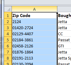
You can go ahead and remove every column leaving only Model & Zip Code untouched. The End Result should look something like this:
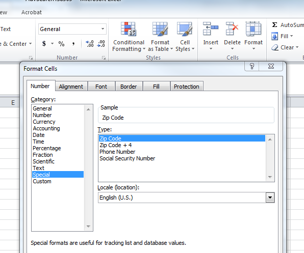
Tip Time (because your head is spinning): You probably aren’t done and most likely you’ll need to format the data in the zip code column (in my experience) it rarely comes out 100% usable. To fix the zip code column highlight the entire column and then…
…with the zip code column selected click on the “Number” menu and once the formatting box opens click “Special” and highlight “Zip Code” then click “Ok”.
Next, SAVE the file again as a CSV text tab-delimited file to your desktop or whatever folder you deem fit. Normally, I will name this file in this way “DealershipName_NewSales_Model_Zip_TimePeriod.csv” so, that it is easy for me to later reference it and compare it to other files in the future.
Now, into the Deep Dive to get Results
With the file saved it’s time to log into your newly created MapsEngine account and drop the file in. On the MapsEngine home screen click the blue button that says “Create a New Map”. Next, click “import” on the left hand menu, select your file and finally select the zip code column to let Google know that you want to put placemarks on each matched zip. On the next screen where you’re asked to choose the column you want to use for titles select, “Model” and, then click finished.
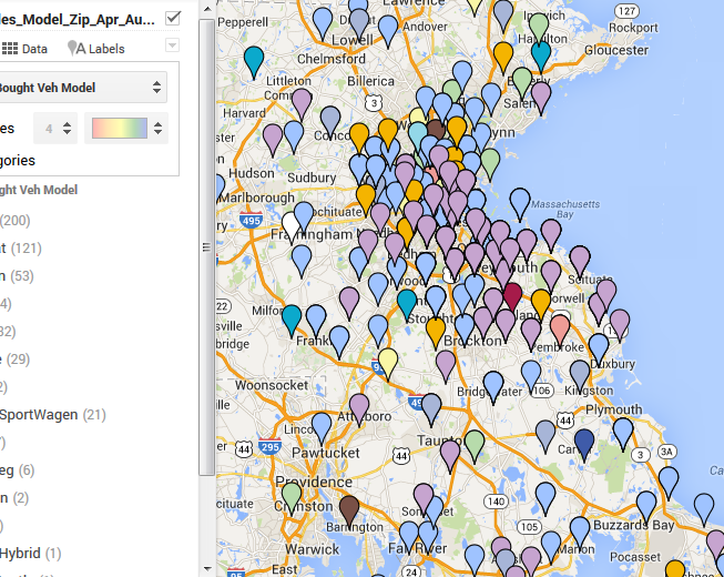
This should load a screen that looks something like this:

To make the data useful click “Style” on the menu panel located on the left hand side of your screen and change from the default “Uniform Style” to selecting “Model”. Instantly your map becomes useful showing you, in variety of colors, where (by zip code) you’re selling New Models. As seen below:
What Will You Do With This GREAT Data?
1.) Use the data to help better select advertising locations in your Adwords account. For example: “I’ve never sold a New VW Jetta in Framingham, MA so do I really need to be spending my Adwords budget to promote our New Jetta offers in Framingham?” At a minimum you should probably consider adjusting the bids.
2.) Compare segments “I seem to sell a lot of Crossovers in Weymouth, MA. Maybe, I could create a landing page on my website that showcases my best offers on all new VW Crossovers to target with Adwords in that area.”
3.) This data should give you an idea of how far, in general, your customers are willing to travel – personally I find that very useful.
Enough brainstorming — let’s get our hands even dirtier!
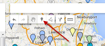
In the search bar floating above the map you should see a little balloon that says “add marker” when you hover over it:
Search for all of your competitors using the search bar and I want you to add all that are inside, as well as, those 10 or so miles outside of your PMA to the map. You do this again by searching and then once MapsEngine drops the pin, click on it and click “Add to Map”. For those ruthless Digital Marketers, you shouldn’t have to go through this process one by one. You’ve already taken your premade CSV file containing all of your competitors Zip Codes | Store Name and added them as a “uniform” colored layer to your map.

Doing this will help you better identify areas of opportunity including taking advantage of weaker dealerships, better segment market places, determining max radius to advertise in, and perhaps what areas and models are the best ones to focus on. Literally there are hundreds of ways to use GEO-coding to your advantage. I promise to go into even more depth with GEO-coding marketing advantages in a later tip.
A Few Pitfalls:
The accuracy of Geo-coded maps is dependent on the accuracy, as well as, the authenticity of the entry data. For example, if some of your staff desks deals calling it a “JETTA” and the other half desks it as “Jetta” then you will see two different models both called “Jetta”. I recommend prior to upload trying to uniform the styling.
Also, you may notice vehicle markers all over the map even in territories you’re positive you’ve never had a sale in. There’s many ways this can happen ranging from incorrect data entry, changing CRM or DMS providers, ghosts in the machine, or even just customers who have moved and shared their new address with the dealership. The way to best use this data is to identify trends in the form of marker clumps that can help steer you to making better digital and traditional marketing efforts.
Now, go take a few aspirin and GET TO WORK!
Current Discussion Topics